Datoteka:Serbia-WW1-4.jpg
Izvor: Hrvatska internetska enciklopedija
Veličina ovog prikaza: 799 × 271 piksela. Ostale razlučivosti: 320 × 109 piksela | 1.023 × 347 piksela.
Vidi sliku u punoj veličini ((1.023 × 347 piksela, veličina datoteke: 99 KB, <a href="/index.php/MIME" title="MIME">MIME</a> tip: image/jpeg))

|
This map has been uploaded by Electionworld from en.wikipedia.org to enable the |
Sažetak
| Opis |
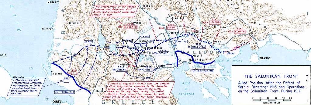
English: Operations at the border of Greece and Serbia, 1916.
his map was created by the Department of Military Art and Engineering, at the U.S. Military Academy (West Point). The initial version was created under the supervision of General Vincent Esposito in 1959. It is now available on the West Point |
||||||
| Datum | |||||||
| Izvor | West Point | ||||||
| Autor | General Vincent Esposito | ||||||
| Dopuštenje (Naknadna uporaba ove datoteke) |
|
||||||
| Ostale inačice |
  |
||||||

Povijest datoteke
Kliknite na datum/vrijeme kako biste vidjeli datoteku kakva je tada bila.
| Datum/Vrijeme | Minijatura | Dimenzije | Suradnik | Komentar | |
|---|---|---|---|---|---|
| sadašnja | 21:55, 21. prosinca 2006. | 1.023 × 347 (99 KB) | Electionworld | {{ew|en|Cglassey}} == Summary == Operations at the border of Greece and Serbia, 1916. his map was created by the Department of Military Art and Engineering, at the U.S. Military Academy (West Point). The initial version was created under the supervision |
Poveznice
Na ovu sliku vode poveznice sa sljedećih stranica: