Datoteka:Serbia1918.png
Izvor: Hrvatska internetska enciklopedija
Veličina ovog prikaza: 370 × 600 piksela. Ostale razlučivosti: 148 × 240 piksela | 586 × 950 piksela.
Vidi sliku u punoj veličini ((586 × 950 piksela, veličina datoteke: 60 KB, <a href="/index.php/MIME" title="MIME">MIME</a> tip: image/png))
| Ova je datoteka sa stranica Zajedničkog poslužitelja Zaklade Wikimedije i smiju je rabiti drugi projekti. Opis s njezine stranice s opisom datoteke prikazan je ispod. |
Sažetak
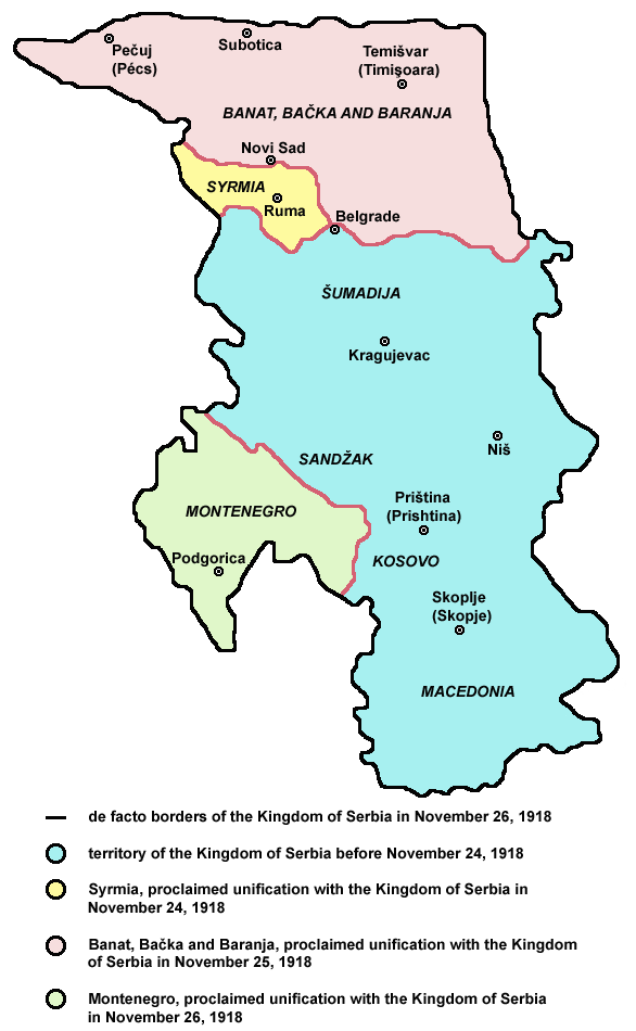
- English: de facto borders of the Kingdom of Serbia in November 26, 1918, after unification with Syrmia (November 24), Banat, Bačka and Baranja (November 25) and Montenegro (November 26), during the process of Creation of Yugoslavia.
- Serbian: фактичке границе Краљевине Србије 26. новембра 1918. године, после уједињења са Сремом (24. новембра), Банатом, Бачком и Барањом (25. новембра) и Црном Гором (26. новембра), током процеса стварања Југославије.

|
This map image could be re-created using vector graphics as an SVG file. This has several advantages; see Commons:Media for cleanup for more information. If an SVG form of this image is available, please upload it and afterwards replace this template with
{{vector version available|new image name}}.It is recommended to name the SVG file “Serbia1918.svg”—then the template Vector version available (or Vva) does not need the new image name parameter. |
References
Published references:
- Drago Njegovan, Prisajedinjenje Vojvodine Srbiji, Novi Sad, 2004.
- Drago Njegovan, Prisajedinjenje Srema, Banata, Bačke i Baranje Srbiji 1918. - dokumenti i prilozi, Novi Sad, 2001.
- Lazo M. Kostić, Srpska Vojvodina i njene manjine, Novi Sad, 1999.
- Dimitrije Boarov, Politička istorija Vojvodine, Novi Sad, 2001.
- Dr Tomislav Bogavac, Nestajanje Srba, Niš, 1994.
- Čedomir Popov - Jelena Popov, Autonomija Vojvodine - srpsko pitanje, Sremski Karlovci, 2000.
- Rade Šumonja, Spomenica oslobođenja Sombora 1918-1998, Sombor, 1998.
Internet references:
- Map archive copy at the Wayback Machine
- Map
- Map archive copy at the Wayback Machine
Licencija

|
This map has been uploaded by Electionworld from en.wikipedia.org to enable the |
Self-made map by WikiEditor2004
| Ovo djelo je u javno vlasništvo izdao autor: WikiEditor2004. To vrijedi za cijeli svijet. U nekim državama to nije pravno moguće; ako je tako: |
Povijest datoteke
Kliknite na datum/vrijeme kako biste vidjeli datoteku kakva je tada bila.
| Datum/Vrijeme | Minijatura | Dimenzije | Suradnik | Komentar | |
|---|---|---|---|---|---|
| sadašnja | 09:48, 24. prosinca 2009. | | 586 × 950 (60 KB) | WikiEditor2004 | aesthetics |
Poveznice
Na ovu sliku vode poveznice sa sljedećih stranica: